Mapas, Cartas MarinasHydrographic Office of the Admiralty" />
Frame
F
C/ General Pardiñas 69,
28006 Madrid, España
Tel.: 34 91 5641519
Fax: 34 91 5641520
Búsqueda
Avanzada
Busqueda Rápida
 
 
Suscríbete a nuestro próximo servicio de Newsletter
 
Mapas
Cartas Marinas
Londres, , 1977
Estampado color, 71 x 104 cms.
(MAP-24254)
330
Comprar
Agregar a Mi lista
Oceania Australia

South Pacific Ocean - CORAL and SOLOMON Seas and Adjacent Seas - Oceano Pacífico Sur

Mapas, Cartas Marinas
Autor / Artista: Hydrographic Office of the Admiralty
Carta náutica del Almirantazgo Británico // British Admiralty Nautical Chart.
[4604.]
 
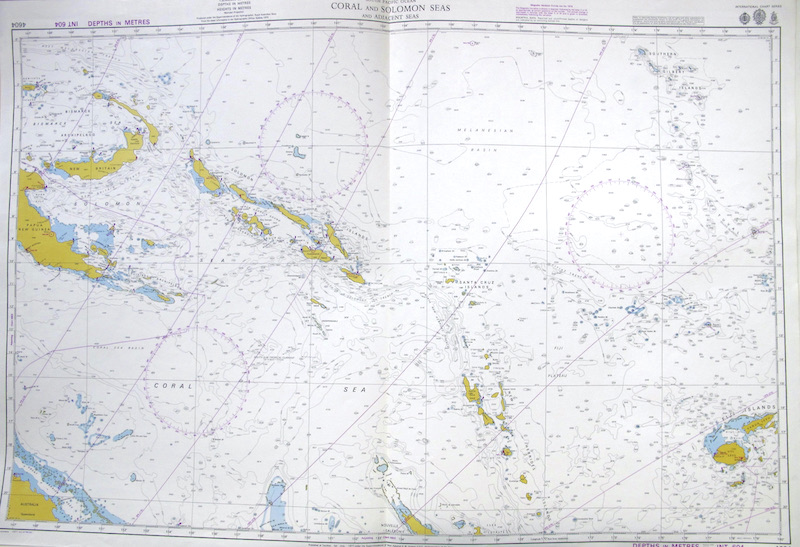
Se representan los territorios de los Mares de Solomón y Coral, al Noreste de Australia.
 

"From the Netherlands Government Surveys to 1953 / With Additions and Corrections from the Indonesian Goverment Charts to 1956" .****

"International Chart Series" / "Magnetic Curves are from 1970"

"Published at Taunton, 1st July 1977, under Superintendence of Rear-Admiral D.W. Haslam, O.B.E., Hydrographer of the Navy / Modified reproduction of INT chat 604 originally published July 1973 by Australia / Crown Copyright 1977".

Además, incluye una correción a tinta ("Small Corrections") realizada durante el uso de esta carta, en 1977.


(c.138)

Destacados
1 . HORARIO 10:00/14:00 - 17:00/20:30 (sábados sólo mañana) Contacto: 91.411.33.62 / info@frame.es
Frame Galeria Madrid
2 . Nuestra Política de Privacidad
Frame Galeria Madrid
3 . VINTAGE POSTERS
1 . No Asignado
4 . CARTAS MARINAS
1 . No Asignado
5 . COLECCIÓN
PIRANESI, Giovanni Battista (1720-1778)
6 . MAPAS de ESPAÑA
1 . No Asignado
7 . COLECCIÓN
Goya y Lucientes, Francisco de
8 . Catálogo de Mapas Murales
Frame Galeria Madrid
9 . Ahora también en Instagram !
Frame Galeria Madrid
10 . Información
Frame Galeria Madrid
11 . Taller de Enmarcación
Frame Taller de Marcos
Noticias
nook Diseño WEB
 
C/ General Pardiñas 69,
28006 Madrid, España
Tel.: 34 91 5641519
Fax: 34 91 5641520

Mail: info@frame.es